The KAPtery closed on December 31, 2024. Products can no longer be ordered from these pages. Some products are available for purchase from Ennapurna in France. For questions, replacement parts, special requests, or leftover inventory, use the Contact page above.
Regaining a perspective
I have been trying to fly the Saturn V Rig into the position where it can take panoramas that recreate the view drawn by the 19th century artists who made "bird's eye views" of towns in Vermont and elsewhere. The old lithographs of these views are detailed snapshots of the past, and my goal is take equally clear aerial photos of the same scenes.
I have tried to retake two of these old views. My second try with L. R. Burleigh's 1886 view of Middlebury, Vermont was better than the first, but I might have to try a third time when there is another warm south wind.
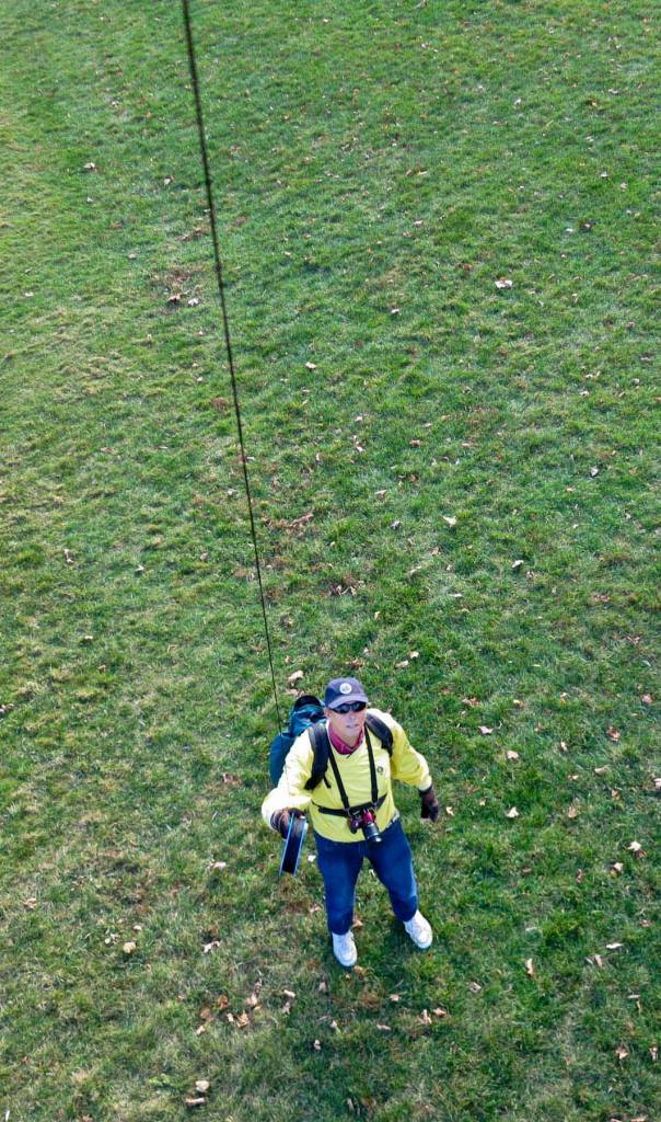 |
| On Battell Beach, November 5, 2015 |
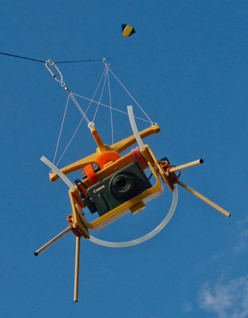 |
| The Fled lifted the Saturn V Rig with a PowerShot S100. The two servos pan or tilt the camera to a new position for each photo and cover the entire spherical scene (except the zenith) in 25 photos every 75 seconds. |
The camera was not high enough on my first two tries, and on the second try it was cloudy so I had to set the ISO to 200 and the shutter speed to 1/640 second to get good exposures. The higher ISO introduces some graininess into the photos, and the slower shutter speed allowed some of the photos to be blurred by motion (I usually try to use 1/800 second). Many of the photos are acceptable, but if I can actually recreate the old views, these could be images that people will want to examine closely. So I hope my next attempt is on a much sunnier day so the camera can capture crisper images.
 |
| The eight blue lines connect buildings or intersections that can be identified in both scenes. They would be parallel if the scenes matched perfectly. The minor discrepancies seem random and are probably due either to errors in the map Burleigh worked from or to his errors in translating the map to a perspective view (which was done by eye and is therefore impressively accurate). Burleigh’s “projection” is somewhat unrealistic because the west side of buildings face the viewer on both the right and left sides of the view (note the three early campus buildings on the far right). For a better view, click the image, then the full screen icon at the top. |
The detail below of the old and new views reveals the fuzziness in the aerial photos. The Canon PowerShot S100 can do better than that in brighter conditions. On a really sunny day I can use ISO 80 and 1/800 second and the aperture might vary between f/4 and F/5.6 which should provide sharper photos. Especially if the wind is steady, I think quality can improve just enough to make it worthwhile to reshoot.
 |
| Detail of Burleigh’s 1886 lithograph (top) and a panorama stitched from two photos taken on Thursday (lower). The Canon S100 can capture crisper photos, but cloudy conditions required that I set ISO to 200 and shutter speed to 1/640 second. For a better view, click the image, then the full screen icon at the top. |
There are two other ways to improve image quality. I could use a better camera. That can be expensive, and I don't have plans to do that. But it can be a lot of work to get a camera into the exact position to get the images I want. Its a shame to invest all that effort and not use the best camera possible.
The other strategy is to zoom the lens a little. The S100 has a very wide angle lens (24 mm equivalent) for a PowerShot. Like all PowerShots, the image quality is reduced near the edges when the lens is at its widest. When the lens is zoomed in just a bit, to about 30 mm or 40 mm, the edges get crisper. But more importantly the resolution of the resulting panorama increases. More photos have to be taken to cover the same scene, and more pixels are being captured. My panorama above of Burleigh's entire view required only three photos. If I use a focal length of about 35 mm I could cover the same scene in only eight photos (with lots of overlap for stitching). That will require a routine on the SkyShield autoKAP controller that just shoots toward the subject of choice and does not try to cover 360°. I have already added such a mode to the basic SkySweep sketch.
I might not have to sacrifice the opportunity to also make a half-spherical panorama. The greatest feature of the SkyShield autoKAP controller is its complete programmability. It is very easy to alter the Arduino sketch so the Saturn V Rig covers just part of the scene for 20 or 30 minutes, then switches to its standard 360° routine for the rest of the flight. I would also have to send a signal to the camera to change the zoom. That requires a CHDK script be running on the camera to detect a unique signal sent to the USB port. I guess it's possible.
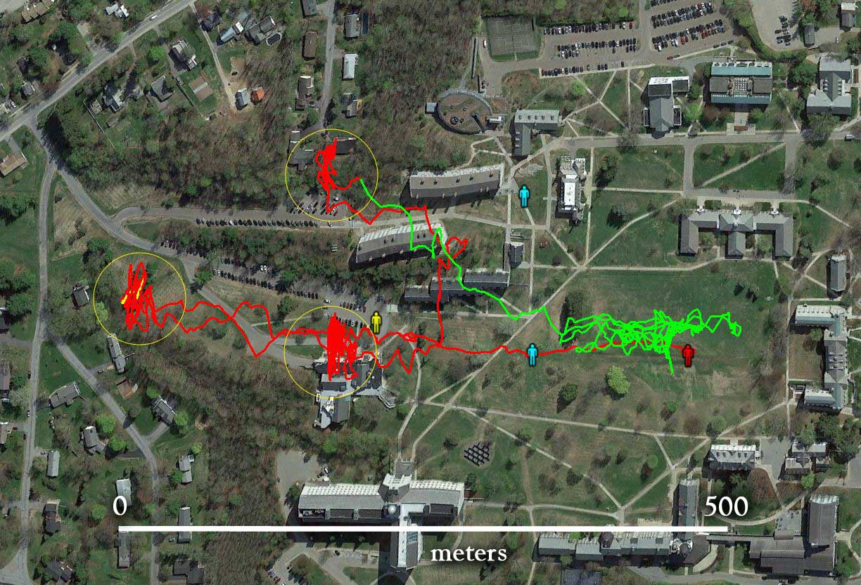 |
| Plan view of the camera tracks from the GPS data recorded with each photo (1421 data points). The kite was launched from the red man and walked to the lower blue man, the yellow man, the upper blue man, and then back to near the red man. The green track is when the kite was being hauled down. At each man, I waited for the Saturn V Rig to complete several cycles of 25 photos each before moving to the next location. That produced three clusters of photo locations (yellow circles). The spherical panorama presented below was taken when the camera was near its northernmost extent (left, yellow trace). |
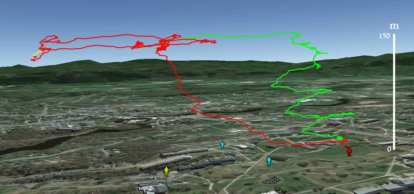 |
| Altitude profile of the camera from GPS data. The red line is the ascent and then the kite being walked around when all the line was out (about 950 feet) and the camera was about 450 feet (150 m) above the ground. The green line is when the kite was being hauled in. The wind had strengthened by then, so in the big quad I wound in line as I walked downwind (to the left) and then dragged the kite upwind before repeating. |
I started displaying the camera's GPS data in Google Earth just for fun, but it has become an important part of the workflow of selecting photos to stitch into panoramas. The GPS tracks make it easy to see which photos where taken at the different extents of the flight. With 1400 photos captured, it's good to have some help selecting which 25 photo cycle of the Saturn V Rig to try to stitch together. There is more about this workflow in another article.
 |
| Little planet projection of an aerial panorama stitched from 25 photos taken by a Canon S100 on a Saturn V Rig lofted by a Fled kite from the Middlebury College campus on November 5, 2015. |
