Dead Creek flying
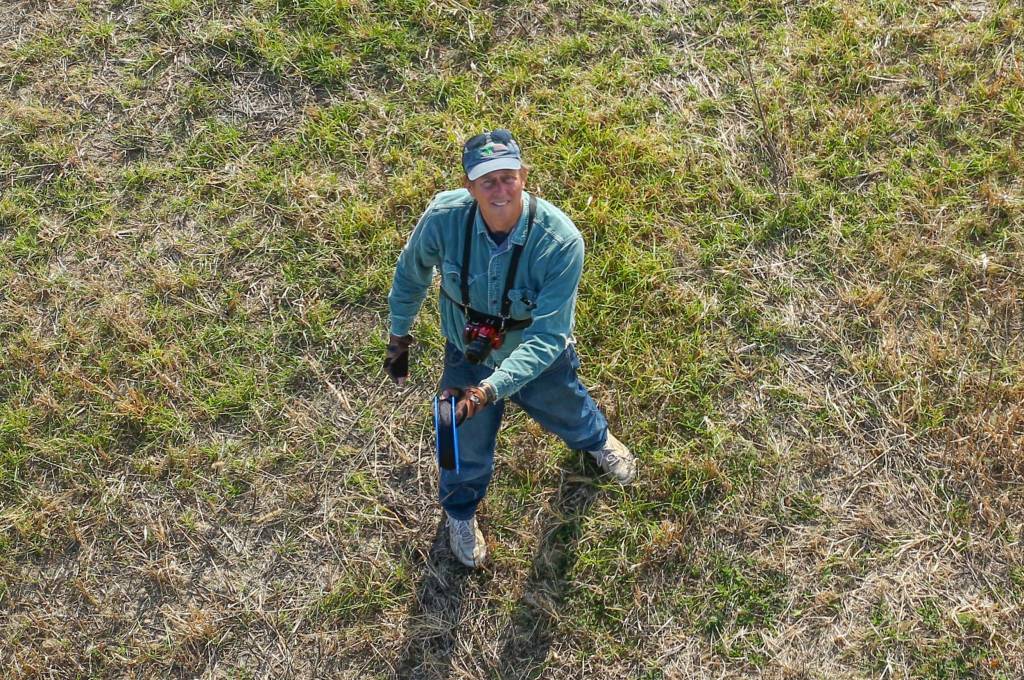 |
| Landing the rig after almost two hours with kites in the air. November 3, 2016. |
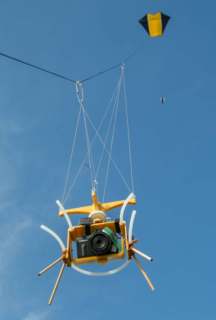 |
| The Fled, the Saturn V Rig, and the Canon EOS M all worked well for an hour long flight during which a photo was taken about every three seconds. November 3, 2016. |
The first day it was sunny but too gusty for effective KAP. I was sorry I had failed to bring the high-wind PFK Nighthawk kite, but the gusts would have made aerial photography mostly unproductive. So I hiked around and admired the huge oaks and big shagbark hickories. I have not spent much time in clayplain forests, and rarely see swamp white oak. There are some huge ones there and also big white oaks. It was a good day for a hike, and I found a big hayfield outside the restricted goose management zone. I was disappointed that there was too much wind.
 |
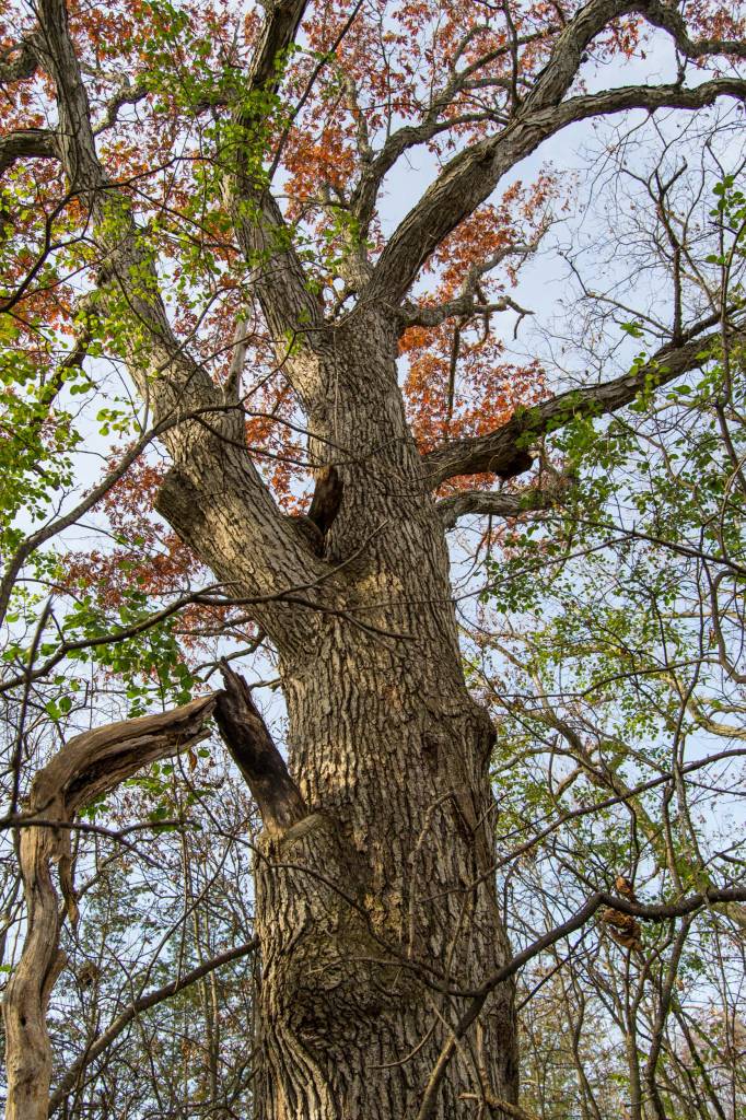
| A very big swamp white oak (Quercus bicolor). The oaks and hickories seem to be older than most of the trees there. |
 |
| A big white oak (Quercus alba). The green leaves are the introduced common buckthorn (Rhamnus cathartica). I think I would have liked these forests better 300 years ago. |
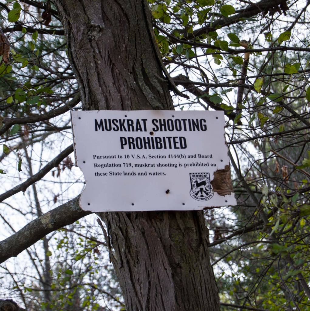 |
| It's called a wildlife management area, but it seems to be the people who are being managed. |
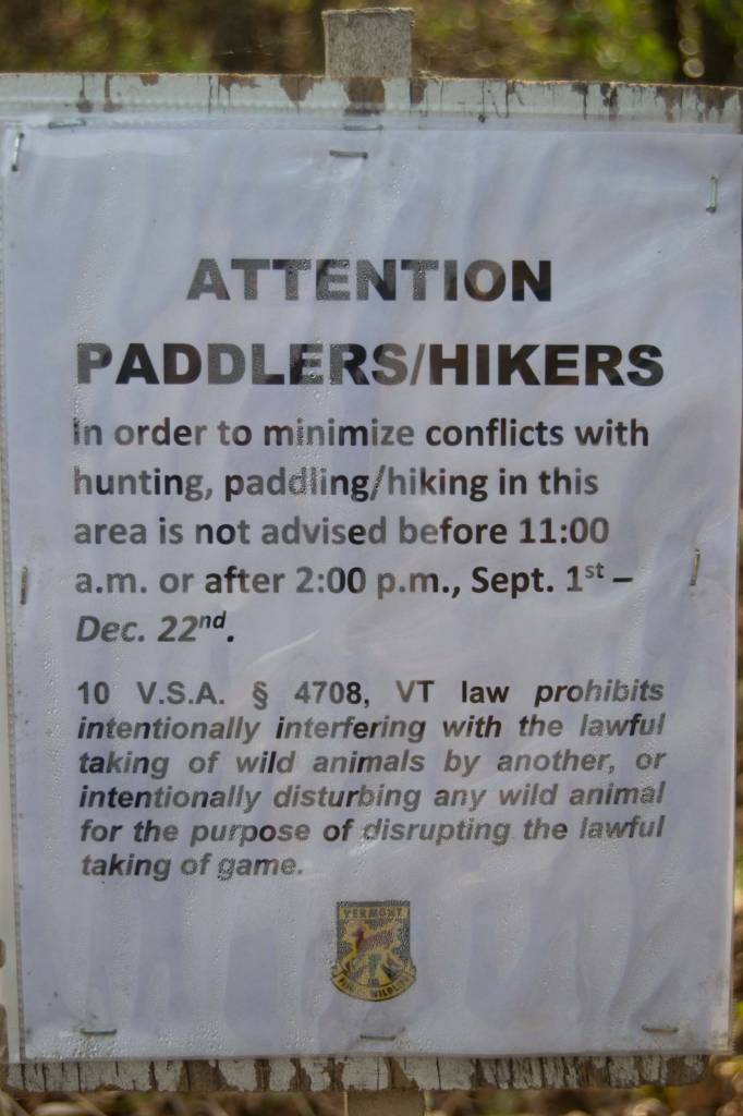 |
| This is a nice way of saying "Proceed at your own risk -- Vermonters with guns are about, and the law is on their side." |
 |
| An interpretive sign showing the tornado of Snow Geese that passes through the Champlain Valley twice a year. |
The next day I went directly to the hayfield and launched the nine foot delta kite before noon. The south wind had calmed down and the delta barely lifted the Saturn V Rig with Canon EOS M, so I switched to the Fled kite. It was so hazy and dim that I set the ISO to 400 and the shutter speed to 1/640, but at the last moment changed them back to my standard ISO 200 and 1/800. That was probably a good decision and most of the photos were taken between f/4 and f/8.
The panorama above is the same stitch as the little planet below. It was stitched in ICE from 33 photos and has a few stitching artifacts. This is a 2/3 resolution panorama from the original EOS M photos. To see it full screen click the icon in the lower right corner.
As the haze burned off the wind was steady and exactly strong enough to keep 1000 feet of line out and let the Saturn V Rig hang calmly under the Picavet for an hour and trigger the shutter 1400 times. I walked to three places I thought might produce good photos and let the rig do its thing at each place for ten minutes or so.
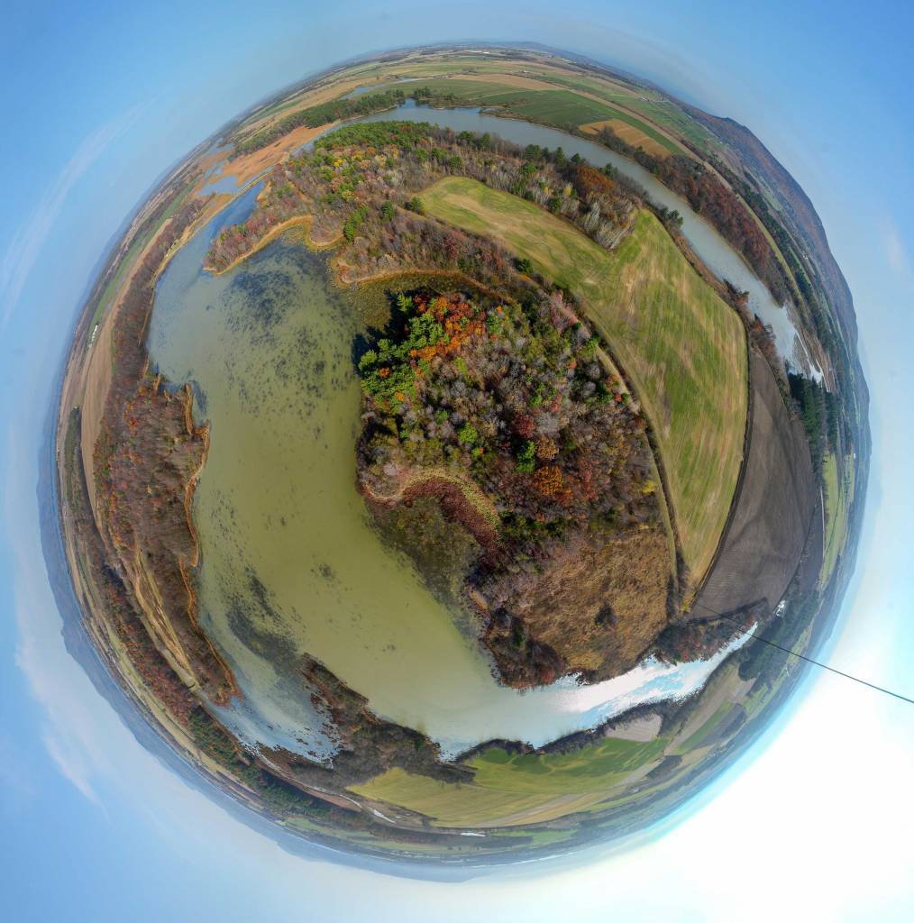 |
| The southern reaches of the Dead Creek Wildlife Management Area. This is a stereographic projection of a spherical panorama stitched from 33 photos taken by a Canon EOS M on a Saturn V Rig. The "Autocomplete" option was used in ICE to fill in gaps in the sky and tiny gaps near the nadir. This is how the panorama was exported from Microsoft ICE. It is the cleanest stitch of a little planet I have ever made, which is strange considering that 20 other sets of photos failed to produce very good panoramas. |
The Canon EOS M must take more than 30 photos to cover the entire 360° scene (five tilt angles), and unless the rig is very steady most of the photo sets do not stitch together very well. I thought the long, smooth flight would produce many well stitched panoramas, but it didn’t. I gave Microsoft ICE 22 different sets of 36 to 39 photos, and only one stitched really well into a spherical panorama. One problem was that the sky was mostly clear, so there was no detail for ICE to grab onto to match up photos in the uppermost rank. Another problem might have been that it was hazy, so the distant landscape was lacking crisp details. The rig is also failing to trigger the shutter sometimes, which is why every set did not have 39 photos in it. I might try slowing down the routine in case the EOS M is not being given enough time to get ready for the next photo.
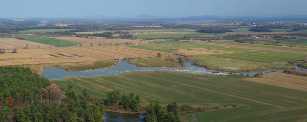 |
| The white dust in the center of this photo is a gaggle of Snow Geese. I was about a mile away when this photo was taken, so each bird is just a few pixels. The news that day was that 1600 to 1700 geese were in that group. This photo suggests that about 3000 birds were present. |
 |
| The canopy of an oak and hickory forest. The areas with small trees and the prevalence of the introduced buckthorn (Rhamnus cathartica) suggests that these forests are recovering from disturbance (probably logging and grazing). Aerial photos at this time of year could allow identification of trees so species maps could be made. The green trees are white pine (Pinus strobus), the purplish red trees are white oak (Quercus alba), and the orange brown trees are mostly swamp white oak (Q. bicolor). Earlier photos would be needed to identify the trees which have already lost their leaves here. |
Flight notes:
Camera:
- Model: Canon EOS M
- ISO: 200
- Shutter speed: 1/800 second (Tv)
- Focus: manual on infinity
- Focal length: 35mm (eq.) EF-M 22mm lens
- White balance: Sunny
- GPS: NA
Magic Lantern:
- Not used for anything
SkyShield:
- Version: 2.4 (3-switch DIP)
- Sketch: SkySweepEOS.04.ino
- Mode: 5 tilt angles with 10, 10, 9, 7, 3 pan positions (upper to lower)
- Shutter triggering: The SkyShield pulsed an IR LED in front of the remote sensor on the EOS M.
- Power: 6 eneloop AAA
- Customization: The nadir tilt angle was changed to 4 so the camera was pointed straight down.
Flight:
- Kite: FLED
- Wind: From S, 7 to 12 mph
- Altitude: About 1000 feet of line was out for most of the flight.
- Duration: 1 hour
- Photos taken: 1400
Panorama stitching:
- Software: Microsoft ICE
- Preprocessing: Some of the photos were lightened in Photoshop before stitching.
- Stitching: 33 of the 39 photos stitched together.
- Post processing: Panoramas at Photosynth cannot be passed through Photoshop so what you see there is what Microsoft ICE produced. The little planet projection above was not post processed.
